
Introduction
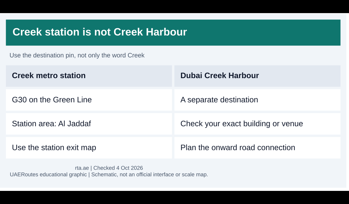
Creek Metro Station is G30 on Dubai’s Green Line, in the Al Jaddaf area. It serves the existing metro network near Dubai Creek. It is not a station inside Dubai Creek Harbour, and the words “Dubai Creek” can refer to several different places in a journey search.
Before travelling, save the precise destination address and compare it with Creek station on the map. This simple check is especially useful for hotel guests, hospital visits and waterfront activities. A landmark across the water may look nearby on a map while needing a separate road journey.
Reach Creek station on the Green Line
Creek is at the end of the Green Line beyond Al Jaddaf. Use the RTA metro station map to check your starting point and any interchange. If you begin on the Red Line, the current map shows Green Line connections at Union and BurJuman.
Read the platform display for the train heading towards Creek. A correct line name is only half of the journey; a train travelling the other way takes you away from the station you need. At an interchange, follow the signs for the Green Line rather than leaving the paid station area unnecessarily.
Keep a nol card with sufficient balance and tap it at both ends of the ride. The metro zones guide explains the fare bands if you are budgeting from a different part of Dubai. Your onward taxi or other separate journey needs to be considered in addition to the metro fare.
Creek station and Creek Harbour are different places
Creek station is an operating Green Line stop in Al Jaddaf. Dubai Creek Harbour is a separate development and destination across the creek area. A booking confirmation containing “Creek Harbour” should not be shortened to “Creek station” without checking how you will complete the trip.
The same caution applies to creek cruises, restaurants and event venues. Ask for the exact entrance or boarding pin, not only the attraction’s name. Water, large roads and fenced sites can prevent a direct walk even when two points appear close together on your phone.
The planned Blue Line guide explains future rail connections around the creek. The Blue Line is under construction as checked in October 2026, so future station graphics should not be used as instructions for a journey today. Keep present services and planned infrastructure separate when choosing your route.
Choose an exit for your onward trip
Check the station’s exit map before leaving. Find the side of the road and the direction that suits your destination, especially if you are meeting a taxi. A driver waiting on the opposite side can turn an easy pick-up into a search for a safe crossing or another vehicle approach.
If you intend to walk, open the pedestrian route rather than judging by the road distance. Look at the full path, including crossings and the destination’s entrance. In hot weather, a route that is short in kilometres may still be uncomfortable if it lacks shade or requires a detour around a large site.
For a bus connection, check the route and stop in RTA’s current journey planner. Do not assume that every bus passing a nearby road stops at the station entrance. Save the stop name and the service direction, then compare them with the sign at the boarding point.
Nearby visits and practical planning
A metro ride can be a useful first part of a trip to the Al Jaddaf and creek area, but choose the station using the exact place you are visiting. For example, Al Boom Tourist Village should be checked by its own venue or boarding instructions. Creek station’s name alone does not establish a convenient walk to that venue.
When meeting friends, share the station name, exit or agreed pick-up point and a realistic arrival estimate. Tell them when you have left the fare gates rather than when your train reaches the platform. That distinction is useful for a taxi or someone driving through a busy approach road.
If mobility or luggage affects your trip, allow time for lifts and a suitable onward vehicle. Ask staff for help if the accessible route is unclear or temporarily unavailable. Choosing a different connection can be more comfortable than forcing a route that looked simple on a small map.
Return service and common questions
Can I use Creek station for Dubai Creek Harbour? You can consider it as part of a wider journey, but it does not put you inside Creek Harbour. Check the current road or public transport connection to your actual destination before boarding the Green Line.
Does the station stay open until every waterfront venue closes? Venue hours and metro hours are separate. Check the last usable service for your travel date and destination, including an interchange if one is needed. Leave time to reach the station from your final stop.
Final thoughts
Use G30 on the Green Line for Creek station, then plan the last part of the journey with an exact address. Distinguishing Al Jaddaf’s operating station from Creek Harbour and future Blue Line plans is the most useful step in avoiding an unnecessary detour.
Featured graphic: original UAERoutes diagram. Service information checked 4 October 2026 against the provider’s published information.


1 thought on “Dubai Creek Metro Station Location and Nearby Connections”